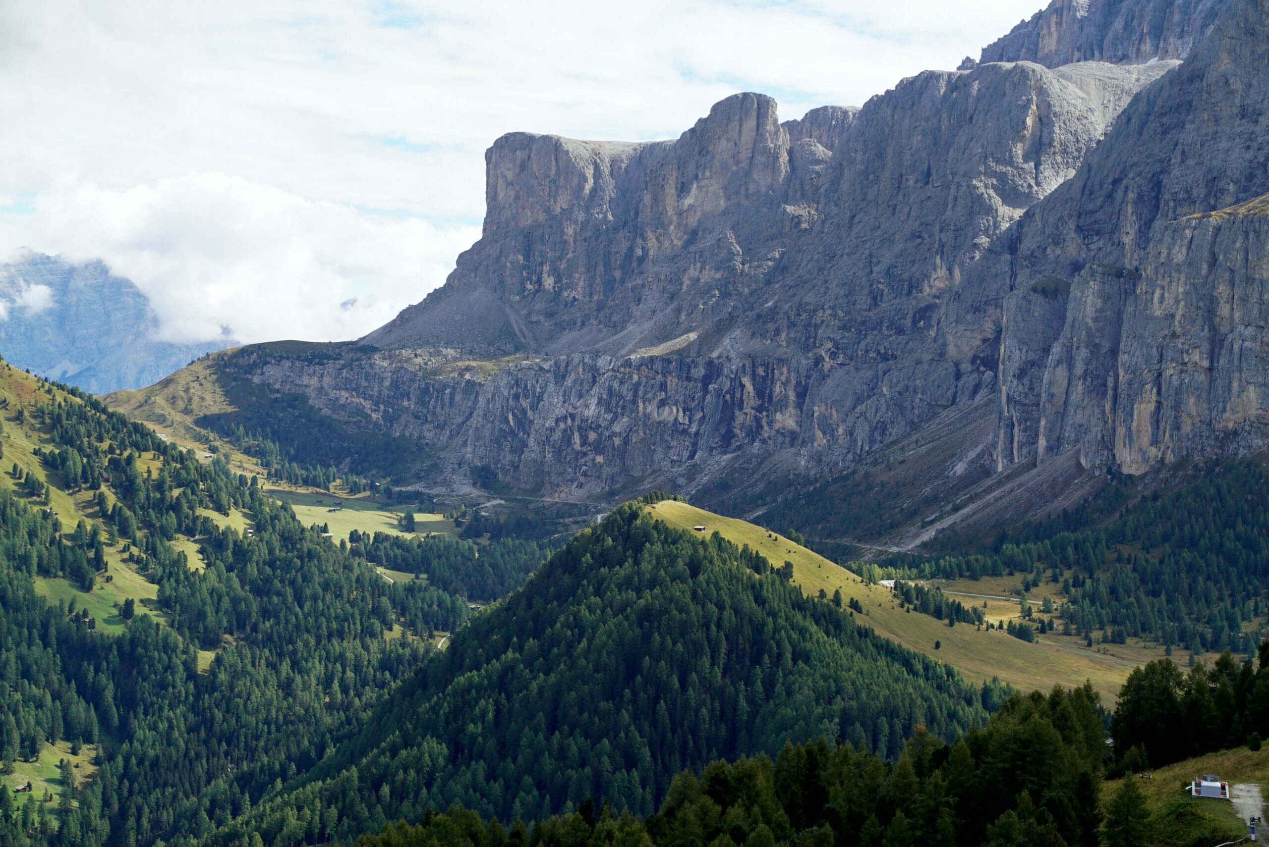
I reach the summit of the Col de Clapier Pass panting for breath, my heart thudding in my chest. At 8,200 feet above sea level in the southern French Alps, the air is little more than a cold, thin gruel. I have been hiking since just after daybreak, passing under snow-covered peaks and ascending nearly a mile in elevation.
At the summit, my guide, Stanford University archaeologist Patrick Hunt, stands on a rocky ledge and sweeps his arm over a view of the Po River Valley. Framed by steep mountainsides, the verdant Italian river plain spreads out like a tablecloth. Peering through a purple haze, I see Turin, some 70 miles away. “Hannibal and his army must have come right through here on their way to Italy,” Hunt says. “It’s hard to imagine, I know.”
Gazing at the surrounding mountains of stone and ice, I find it almost impossible to imagine that a large army could have crossed these peaks; so did the ancient Romans, who called the Alps the “Fence of Italy,” and were unable to conquer the Celtic tribes who lived there for centuries. But in late October 218 B.C., battling snowstorms, rock avalanches, and bellicose tribes, the Carthaginian general Hannibal marched some 25,000 men, 37 elephants, and scores of pack animals over one of the mountain range’s narrow passes. Hailed as one of the boldest military maneuvers in history, Hannibal’s invasion of Italy almost destroyed the young Roman Republic.
While ancient historians wrote countless books about Hannibal’s battle for Rome, the name of the Alpine pass does not appear in any of the texts, and for more than two millennia, the Carthaginian army’s route has been a tantalizing question. “Most historical questions don’t have this aura of mystery and legend,” says Hunt. But now, after a decade of hiking Alpine passes in France, Italy, and Switzerland, Hunt believes that he may have found Hannibal’s pass. Using everything from ancient texts to satellite images, he argues that Hannibal’s army trekked over the exact trail we have been hiking. And next year, he hopes to excavate at the summit of the pass and find the remnants of the massive Carthaginian army that moved through these mountains.
Sitting just below the crown of the pass, Hunt pulls out a copy of Polybius, a near-contemporary of Hannibal who chronicled the general’s exploits. Over the whipping wind, Hunt shouts out a passage.“[Hannibal] noticed that his men were in a state of low morale. He depended on the actual view of Italy, which lies so close to these mountains. He restored their spirits by showing them the plain.”
The text matches up with the view: The pass stands directly over the plains of the Po River and its vista of northern Italy would impress even the most exhausted hiker. Hannibal’s men certainly would have needed the panorama’s inspiration. With grades exceeding 70 percent, the Clapier’s descent is far more dangerous than its ascent. The ancient texts say hundreds of Hannibal’s men slipped to their deaths on the vertiginous path down the Alps. With. the thought spinning in my head, I stand up and begin the climb down, hoping not to join Hannibal’s fallen.
When Hannibal marched across the Alps, he wanted to do more than conquer Italy: He hoped to raze Rome. At the time, Carthage and Rome were jousting for supremacy over the Mediterranean in a century-long series of bitter battles known as the Punic Wars. Located in modern-day Tunisia, Carthage’s empire covered most of North Africa and Spain, while Rome had secured most of Italy and parts of Gaul.
To attack Rome, Hannibal assembled in Cartagena, Spain, one of the largest armies the ancient world had yet seen. With mercenaries from Numidia and Libya, his force at one point numbered as many as 90,000. He also marshaled an elephant corps, which he deployed as an early version of shock and awe, releasing the animals at the very start of a battle to intimidate enemy troops.
While Hannibal hoped to traverse the Alps during the summer, he battled various Gaulic tribes en route and instead ended up crossing in late October. As the Carthaginian army marched over trails choked with snow and ice, Celtic tribes repeatedly ambushed them in narrow, boulder-riddled defiles. The extreme cold also caught the army by surprise. As much as a third of Hannibal’s men died during the weeklong Alpine expedition.
When Hannibal finally stepped onto the plains of northern Italy, his army looked more like animals than men, writes Polybius. But even with a small, weakened force, Hannibal repeatedly defeated the Romans. (None of Hannibal’s nearly two dozen elephants, however, survived the first year in Italy.) At the Battle of Cannae, his army encircled a Roman force nearly twice its size, slaughtering more than 50,000 men in an afternoon. After a series of victories, Hannibal hoped that other Italian city-states would join his fight. But the gambit failed, and over time, the Romans slowly ground down Hannibal’s army through bloody attrition. In 202 B.C., the Romans decisively defeated Hannibal at the Battle of Zama.
While much attention has been devoted to Hannibal’s passage through the Alps, no one has conclusively proven the army’s route. The problem is a lack of primary evidence: Neither Hannibal nor his commanders wrote any surviving tell-all accounts. Besides an elephant skeleton and a Carthaginian coin found at the very edge of the Alps near Avignon, France, in the late eighteenth century, no artifact—not a single Carthaginian trinket—has been discovered in the mountains.
The Ancient Texts. A few ancient texts provide almost all that is known about the expedition. The oldest and most reliable account comes from Polybius, who interviewed some of the general’s companions and retraced Hannibal’s route through the Alps a few decades after the crossing. The other major source is the Roman author Livy, who wrote a century later and depended on Polybius and other contemporary accounts for his narrative.
Since antiquity, scholars have matched the ancient texts against the features of the southern Alps to try and identify Hannibal’s pass. But few theories have gained much support, and historians have continued to search for the route, some trying to recreate Hannibal’s journey in order to gain a new perspective. In 1959, for instance, an Oxford University engineering student, John Hoyte, rode an elephant over the Mount Cenis Pass to understand how Hannibal might have crossed the mountains with a battle-ready pachyderm. Among other things, Hoyte showed that an elephant could withstand the altitude and cold of the Alps, something some scholars had doubted. But there’s no question the trip was strenuous: With a daily ration of 150 pounds of hay, 50 pounds of apples, 40 pounds of bread, and 20 pounds of carrots, Hoyte’s elephant, Jumbo, still lost 300 pounds during the trip.
To be sure, some scholars do not believe that determining Hannibal’s precise route has much historical significance. Searching for the pass, they argue, is like researching which pier George Washington used when he crossed the Delaware River: Who cares? Even some Hannibal pass researchers admit the point. “The route itself isn’t that important. We know that Hannibal crossed the Alps. That’s what matters,” says Eckerd College military historian John Prevas. “We historians get bored. This gives us an excuse to get out of our offices and do something.”
But Hunt and other scholars argue that finding the pass would give them a better understanding of the condition of the Carthaginian force in Italy—if the army trekked over a 10,000-foot pass, then even the men who survived would have been near death. Identifying Hannibal’s pass would also give archaeologists a chance of finding traces of the invasion, as well as yield greater insight into the ancient general’s military strategy by showing what he was willing to sacrifice to achieve his dream of destroying Rome. “You get a real sense of who Hannibal is—the risks he took—by studying the pass,” says Hunt.
When Hunt was a teenager in San Diego, he read a history of Hannibal in an encyclopedia. Impressed by the daring of the Carthaginian general, he soon began searching out all things Hannibal, from ancient texts to Roman paintings. “There’s this aura around Hannibal,” says Hunt.“Nothing seems to stop him, even nature itself seems just another obstacle that he can surmount.”
But Hunt didn’t believe that he could make a career out of his passion, so he combined his interest in ancient history with earth sciences and earned a Ph.D. in geoarchaeology at the University of London. Then in 1994, while Hunt was surveying a Roman temple near the Grand St. Bernard Pass in the Swiss Alps, he heard locals talk about how Hannibal had passed through the area. (Joel Ble, one of the expedition’s Swiss mountain guides, later explained to me that in the Alps, “every person thinks Hannibal came through their village. It’s like every person thinks that their village is the most beautiful.”)
To solve the question of where Hannibal crossed the mountains, Hunt began reading Polybius and Livy and searching for passes in the southern Alps that fit with the texts. Over the past decade he has hiked almost all the potential sites from the Grand St. Bernard Pass to the Col de Montgenèvre.“I think there have been too many armchair historians looking at this,” he says.“Doing it on foot, so you can see everything from the ground level up, makes a huge difference.”
Hunt has also tried to understand how the Alpine environment may have changed over the past 2,000 years to help connect the modern topography to the ancient one detailed in the texts. Polybius, for instance, writes that Hannibal camped below a “bare rock place” before ascending the pass. So Hunt has attempted to find the exact rock face and has taken stone samples to understand how erosion and weathering might have changed the spot over time. Hunt also studied pollen counts, which provide perspective on the ancient environment: If the tree line was lower, then the pass was colder in antiquity, an important detail, says Hunt, since Polybius states that Hannibal’s men found snow from the previous winter at the top of the pass. “Either people are looking in the wrong places, or they are looking in the right places and the landscape has changed,” he says.
The work has taken a toll on Hunt’s 55-year-old body. He has broken more than a dozen bones from unexpected tumbles on the Alpine slopes. He continues hiking the mountains every summer. Last August, I spent a week with him and a few Stanford students as they examined potential passes of Hannibal.
Because of the distances and landmarks described in the ancient texts, Hunt and other scholars have long believed that Hannibal crossed the Rhone River near Valence, France, and then moved east, following the Isere River toward the mountains. Along the way, the army ran into ambushes, some of which were set up by Hannibal’s duplicitous guides who hoped to strip his army of its provisions and pack animals.
An Alternate Path. A few years ago, however, John Prevas argued for an alternative passage. Instead of following the Isere River, Prevas believes that Hannibal followed the Drone River and then crossed the mountains at one of the highest passes in the southern French Alps, the Traversette. After hiking the area for years, Prevas argues that the Traversette best fits the description in the ancient texts, from the details of the bare rock place to the year-round snow on the summit. Most notably, the pass offers the stunning vista described by Polybius and Livy, says Prevas. “My god, the view is incredible. It’s like being on a roller coaster. You get to the top, and it takes your breath away,” he says.
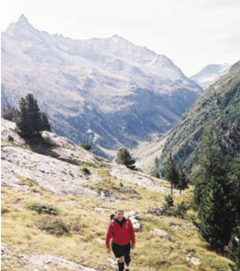
On a sunny Saturday morning, Hunt and I hike the trail from the bottom of the Queyras Valley up to the Traversette pass. Hunt had attempted the climb a few years earlier but stopped halfway when a storm—thick with snow and 50- mile-per-hour winds—rolled through the valley. But the first few hours of our hike are relatively easy. We walk along emerald green pastures, watching marmots and chamois dart along the high ridge lines.
But the last few miles of the trail make me wish for the other end of Hannibal’s sword. To climb the summit, we clamber along a schist-filled trail as it weaves around the bottom of a cavernous glacial cirque. And while that was hard, the final 500 feet are almost insurmountable: We crawl a near vertical talus slope that slides with each step. Indeed, the experience was so arduous that one of Hunt’s students, an ex-Stanford football player, found it just as taxing as playing lineman in Division IA. The summit is as inspirational as Prevas described. A 30-foot notch in a row of narrow, basalt needles, the spot offers a long, sweeping panorama of the Po River Valley, with clouds floating below us. But Hunt has reservations. “This is too steep for an army. Suicidal, really,” he said, as we stand at the crown of the pass looking into the valley.
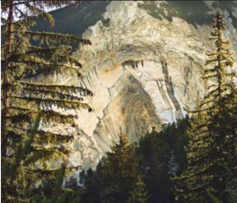
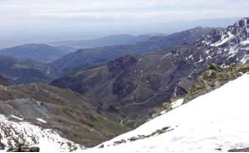
Bound by mountains on one side and 1,000-foot cliffs on the other, the path up the Clapier is often just a few feet wide; even a small rock avalanche can dramatically alter our understanding of how Hannibal might have crossed the pass. Building on existing data like the satellite image of the Clapier above, Hunt plans to work with the software company ESRI to create a 3-D model of the pass as it looked 2,400 years ago. To recreate the topography, the team will study the types of rock along the pass and use computer programs to figure out how the area, a mix of various types of phyllite and schist, has eroded over time, then use geological research on their erosional properties to figure out how the pass might have looked to Hannibal.
A few moments later, as we descend the other side of the pass, Hunt almost proves his point: He slips on a rock and tumbles forward. For a very long moment, it seems as if he will fall 1,000 feet. But guide Bruno Martin catches Hunt’s shoulder and pulls him back from the precipice.
Hours later, safely in the valley, Hunt explains his doubts in greater detail. “Traversette could only work for Hannibal if it were under a glacial cover on both sides, which is almost
impossible to imagine at that time,” he says. Over the next year, Hunt plans to conduct more research, consulting topographical maps and looking at pollen studies, which can help date glaciers. Right now, he believes that it may have been 18,000 years or more since a glacier covered both sides of the pass, and if there was not a dense ice mass covering the area, the slope would be far too steep for a large army, says Hunt “And forget elephants.”
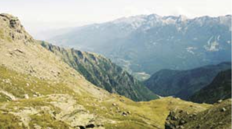
After a decade of research, Hunt is almost sure that Hannibal trekked over the Clapier, and so early one Wednesday morning, we hike the pass together. At almost two miles above sea level, the Clapier Pass is one of the highest in the Alps, and even in August, storms can roar through the Cenis Valley below with 60-mile-per-hour winds and thick, blinding snow.
But as we start, it seems like we are walking into a scene from The Sound of Music rather than Into Thin Air. In the middle of the valley, a larch forest lies dappled with bright August sun, and along the lush mountainsides, cows languidly watch us, while the sound of their bells rings through the valley. While the narrow, rocky trail is far from deadly, it is difficult, and we hike five long hours to reach the summit.
As we arrive at the narrow crown, Hunt explains how the pass meets all the features described in the ancient texts: a wide view of Italy, pockets of year-round snow, and a large campground. There’s also a small lake, and certainly, the army of elephants would have needed the water. Hoyte reported that Jumbo drank 50 gallons of water daily during the hike over the Alps. Polybius also described a harrowing descent, and the climb down the far side is extraordinarily steep—almost vertical at some points. We descend more than 6,000 feet in elevation before we reach the bottom of the pass.

Still, Prevas and other scholars have doubts about Clapier. Most notably, they wonder if Hannibal and his men came up the Cenis Valley, why didn’t they go over the Petit Mount Cenis, which splits off from the approach and is a much easier crossing? “Why do that awful descent,” asks Prevas, “when in an hour and a half, you can be down Mount Cenis?”
Hunt believes that Hannibal didn’t take an easier route because his Celtic guides purposefully misguided him. In the end, he admits that the debate might not be resolved if scholars only have textual evidence.“It’s possible that no one has found Hannibal’s pass because we are reading Polybius too literally,” says Hunt. “But it’s all we’ve got right now.”
This year Hunt plans to gather a group of European archaeologists and excavate the Clapier’s summit and descent, as well as some sites at the Traversette. No digs have been conducted at either pass. Hunt is certain that if Hannibal’s men passed through the Clapier, he’ll find some traces of the army along the descent of the mountain since so many men and elephants would have died hiking down the steep valley.
The excavations will not be easy or cheap. Driving to the top of either pass is impossible and Hunt will have to helicopter in many of his supplies. Because of freezing temperatures, the excavations will be limited to August. Hunt has overcome such obstacles before, and he knows how to work in a high, cold climate. To account for constant erosion and rockfall, Alpine archaeologists must search wide and deep for artifacts. They also must cope with constantly changing weather. “Most archaeologists don’t want to do this kind of work. It’s dangerous. It’s expensive,” Hunt says.“You are constantly fighting the climate and the altitude.”
But the Alpine environment does allow for remarkable finds—the reduced oxygen levels and freezing temperatures slow down decomposition, leaving organic and metal artifacts in excellent condition after millennia. Yet even if Hunt does discover a Carthaginian shield or an elephant tusk sticking out from a snowbank one summer afternoon, it might not lay the debate to rest. In 207 B.C., Hannibal’s brother, Hasdrubal, marched an army and a dozen elephants over the mountains to provide reinforcements, so any unearthed artifact would need some contextual evidence, such as campaign coins, to show that the find was from Hannibal’s army.
Still, Hunt is hopeful. “I believe the time is right, scientifically, methodologically, to make Hannibal’s route more than just a guess, to really prove it,” he says. “I don’t deny it. That is my dream.” ■
By Ulrich Boser and published in the January/February 2007 edition of Archaeology.
Update: Since this article was published, Patrick Hunt published a book titled “Hannibal” on the topic. If you want to visit the pass yourself, check out All Trails
Leave a Reply